


トップ > 市の組織 > 教育委員会 > 生涯学習部 > 生涯学習振興課 > 【国指定名勝,天然記念物・地質】 下地島の通り池
【国指定名勝,天然記念物・地質】 下地島の通り池
〔しもじしまのとおりいけ〕
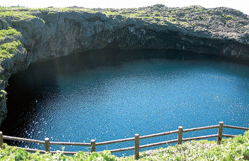
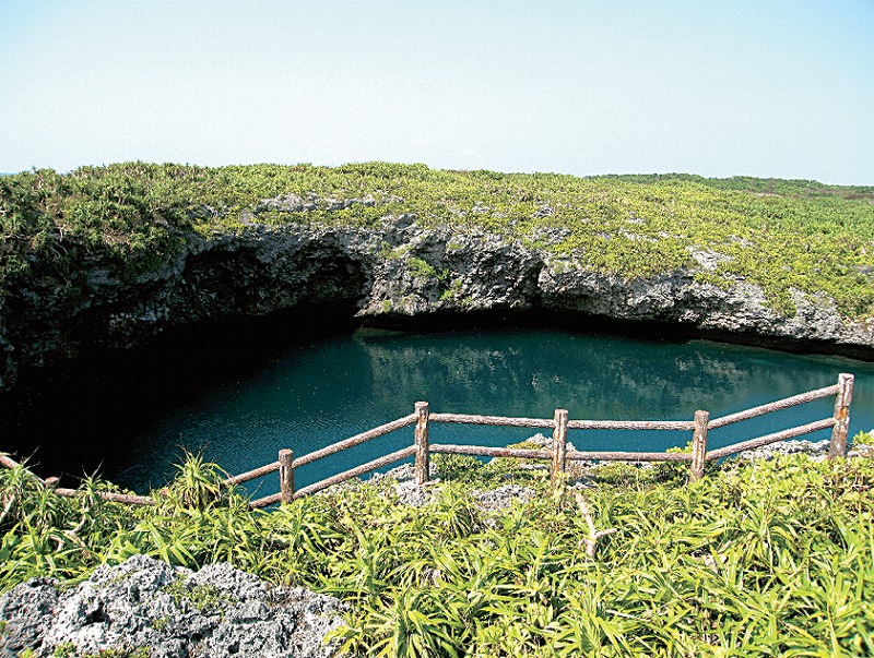
通り池は、2つの池が相接し、天然の橋によって通じている。東北側が直径約55mで水深約25m、南西側が直径約75mで水深は海側が約40mである。直径約10mの海底洞穴で海と通じており、両池は潮の干満で水深が変化する。池の成因は琉球石灰岩が長年の間に海と通ずる鍾乳洞を生じ、その2ヵ所が崩落して天然橋で結ばれる形となったと考えられている。
この通り池は、海底に開口した海食洞と連結した陥没ドリーネとして言われている、下地島には、この外「ナガビダイキ」「ガーナイキ」「オコイキ」「パサマイキ」など海食棚形成期に取り残されたドリーネ状の地形があって、地質、地形学において貴重なところが多い。本池には、昔、漁夫が海の霊を釣り上げ、その罰として津波におそわれ、漁夫の屋敷跡が陥没して池になったという言い伝えや、継子と間違えて実子を池に突き落としたという伝説もある。名勝地としても知られ、青々と海水をたたえたその神秘的な景観は全国的にも珍しく、また石灰岩特有のカルスト地形、環境に適応した海岸植物群落は自然のすばらしさを教えてくれる。
【Place of Scenic Beauty, Natural Monument (Geology) Designated by the Nation】 Tooriike Ponds of Shimoji Island
Toorike are two ponds connected by a natural bridge. The northeastern side is approximately 55m in diameter and the water depth is about 25m. The southwestern pond is approximately 75m in diameter and the depth of the water on the side closer to the ocean is approximately 40m. An underwater cavern that is about 10m in diameter connects the ponds to the ocean and their depths change according to the ebb and flow of the tide. The ponds were created as stalactite caves formed over a long period of time in the Ryukyu limestone, which connected to the ocean, and two areas of the cave fell and formed a natural bridge.
This Tooriike is said to be a subsidence doline, connecting to an underwater sea cave. Besides this location, Shimoji Island has other doline geological features which remain from the formative period of abrasion shelves, like the Nagabidaiki, Ganaiki, Okoiki, and Pasamaiki, which are valuable in the fields of geology and geomorphology. There are several legends related to the twin ponds. One tale tells of fishermen who caught a spirit of the seas, and to punish them, the seas attacked with a tsunami, destroying the fishermen’s homes and the ponds were created where their houses once stood. Another legend speaks of a person who mistakenly pushes their own child into the pond, thinking that the child was their stepchild. The Tooriike is known for its spectacular view. With the mystic blue seawater, its beauty is a rare sight even within the nation. The location also teaches us the splendor of nature, with the karst features unique to limestone geology, and the coastal vegetation communities that adapt well with the environment.
【國家指定名勝天然紀念物・地質】 下地島的連通池
連通池是由相連的两個水池通過天然的橋樑連接而成。東北側的水池直徑約55m,水深25m;西南側的直徑約75m,靠海一邊的水深為40m。通過直徑約10m的海底洞穴與海相連,兩池的水深會因潮水的漲退而發生變化。水池被認為是由琉球石灰岩經過長年累月形成一個與海相通的鐘乳洞,其中兩處地方崩塌,通過天然橋樑連接而成的。
這個連通池據說,是一個與朝向海底張開大口的海蝕洞連在一起的岩溶漏斗。下地島還有「那伽比達伊起」、「伽那伊起」、「奧可伊起」、「帕撒馬伊起」等,從海蝕棚形成期遺留至今的漏斗狀地形,這些地形在地質和地形學上都很珍貴。圍繞這個連通池有很多傳說。過去,有位漁夫因為釣起了海裏的神靈而受到懲罰,漁夫的房屋遭到海嘯的衝擊而陷沒變成池子;還有個錯把親生的兒子當成繼子,推入池中的故事。連通池作為名勝地也很有名,池裏溢滿了碧藍的海水,其神秘的景觀在日本全國也屬少見。另外,石灰岩獨特的喀斯特地形和適應環境的海岸植物群落,都向人述說著自然的美好之處。
【정부 지정 명승, 천연 기념물・지질】 시모지섬의 도리 연못
도리 연못은 두 군데의 연못이 서로 인접하여 천연의 다리로 연결되어 있다. 동북쪽이 직경 약 55m로 수심은 약 25m이고, 남서쪽이 직경 약 75m로 수심은 바다쪽이 약 40m이다. 직경 약 10m의 해저 동굴로 통하고 있으며, 두 연못은 바닷물의 조수 간만으로 수심이 변한다. 연못이 만들어진 것은 류큐 석회암이 오랫동안 바다와 접해져 있던 것에 연유한다. 종유동이 생겨, 두 곳이 붕괴하여 천연 다리로 연결된 것이라고 추측된다.
도리 연못은 해저에 열린 해수 침식 동굴과 통하는 함몰 돌리네라고 불린다. 시모지섬에는 이 외에도 “나비키다이키”, “가나이키”, “오코이키”, “파사마이키” 등 해식붕海食棚 형성기에 남겨진 돌리네 상태의 지형이 있어 지질학적으로, 지형학적으로도 귀중한 곳이 많다. 먼 옛날, 이 연못에서 어부가 바다의 신을 낚게 되었는데, 그 벌로 쓰나미가 몰려왔다고 한다. 그 결과, 어부의 집과 부지가 함몰되어 연못이 되었다는 전설과 친자식을 의붓자식으로 착각해서 연못에 밀어 떨어뜨렸다는 전설도 전해지고 있다. 명승지로써도 알려져 있고, 푸른 바닷물의 신비로움은 전국적으로도 드문 경관이다. 또한 석회암의 특유한 카르스트 지형과, 환경에 적응한 해안 식물 군락은 자연의 수려함을 보여준다.
![]()
生涯学習部 生涯学習振興課
電話:0980-72-3764