


トップ > 市の組織 > 教育委員会 > 生涯学習部 > 生涯学習振興課 > 【市指定史跡】 アブガーNo.2
【市指定史跡】 アブガーNo.2
〔あぶがーNo.2〕
アブガーNo.2は、伊良部島南側の長山の農道78号線の中頃から北に450m程のアブガーNo.1の東側の道路の傍にある。深さは11.5m程で、下部の広さは幅10m、長さ20mで、下部の北東部には階段があり、容易に洞底に降りることができる。床は、ほぼ水平で、階段の下はセメントで整地されており、広間の北西分は、つらら石の4m程のものも見られる。
2次生成物が発達し、相当量の土や植物が堆積している。広間の南側(道路側)には、洞口に半円状の溶食跡があり、その下部には、不自然な落盤状の散岩と土の混ざった小山があり、その奥の方にもつらら石が発達している。
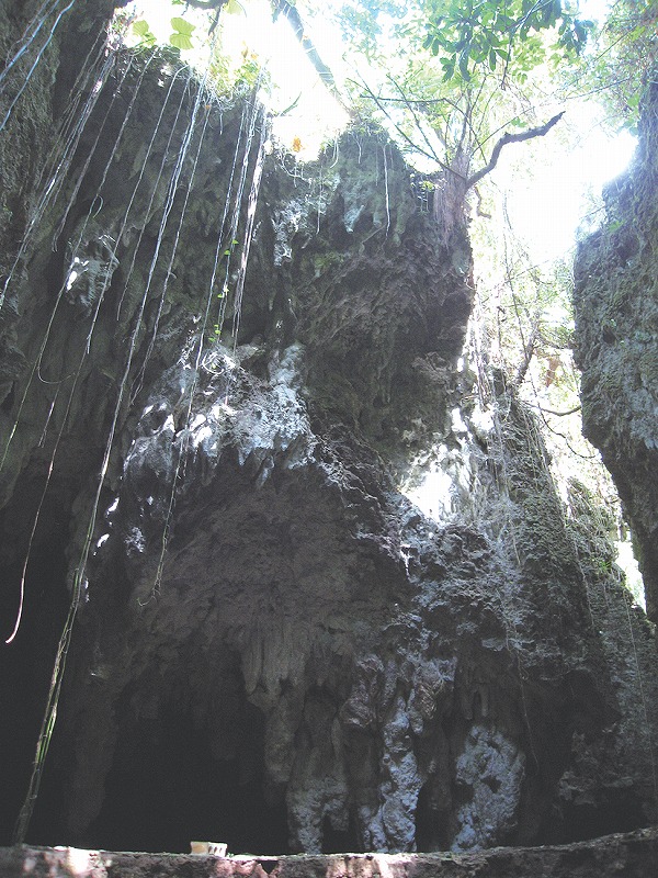
【Historic Site Designated by the City】 Abu-ga No. 2
Abu-ga No. 2 is located by the road east of Abuga No. 1, which is about 450 m north of the midpoint of Farm Road 78 in Nagayama, south of Irabu Island. It is about 11.5 m deep and the space at the bottom is 10 m wide and 20 m long. There is a stairway at the northeastern side of the lower part, giving easy access to the bottom space. The floor is almost flat and covered with concrete around the steps. There can be seen icicle-shaped stones about 4 m in length around the northwestern side of the room.
Secondary products have developed there with a substantial amount of sediment of soil and vegetation. On the western side (the road side) of the space, there is a semicircular trace of corrosion at the mouth. Below it, there is a small rise, a mixture of soil and rocks scattered unnaturally as if they had caved in.
【市指定史跡】 阿布伽二號洞穴
阿布伽二號洞穴位於伊良部島南邊,長山農道78號線的中部以北450公尺處,阿布伽一號洞穴的東側道路旁。深度約為11.5公尺,下部空間的寬度為10公尺,長20公尺,東北部有個階梯,很容易就下到洞底。地面幾乎呈水平狀,階梯下的地面曾用水泥平整過,空地的西北角可以看到4公尺左右的冰柱石。
洞穴沉積物非常發達,有相當數量的泥土和植物堆積在此。空地南側(道路一側)的洞口處,有個半圓形的溶蝕痕跡,下方有些不自然的塌陷狀散岩和泥土混雜的小山,空穴深處也有許多冰柱石。
【미야코지마시 지정 사적】 아부가 No. 2
아부가No. 2는 이라부섬 남쪽의 나가야마 농도 78호선 중간에서 북쪽으로 450m 지점 아부가No.1의 동쪽 길가에 있다. 깊이는 11.5m, 하부 넓이는 폭 10m, 길이 20m이다. 아래의 북동쪽에는 계단이 있어, 어렵지않게 동굴 밑으로 내려갈 수 있다. 바닥은 거의 수평이며, 계단 아래는 시멘트로 다져져있다. 넓은 공간 북서쪽에서 4m정도의 종유석도 볼 수 있다.
2차 생성물이 발달하여, 상당한 분량의 흙과 식물이 있다. 넓은 공간 나쪽(도로측)에는 동굴 입구의 반원 모양의 침식작용 흔적이 있다. 그 아래쪽에는 부서진 바위와 흙이 섞여 산처럼 높게 쌓인 곳이 있고, 그 안쪽에도 종유석이 발달되어 있다.
![]()
生涯学習部 生涯学習振興課
電話:0980-72-3764