


トップ > 市の組織 > 教育委員会 > 生涯学習部 > 生涯学習振興課 > 【国指定:名勝】東平安名崎
【国指定:名勝】東平安名崎
〔ひがしへんなざき〕
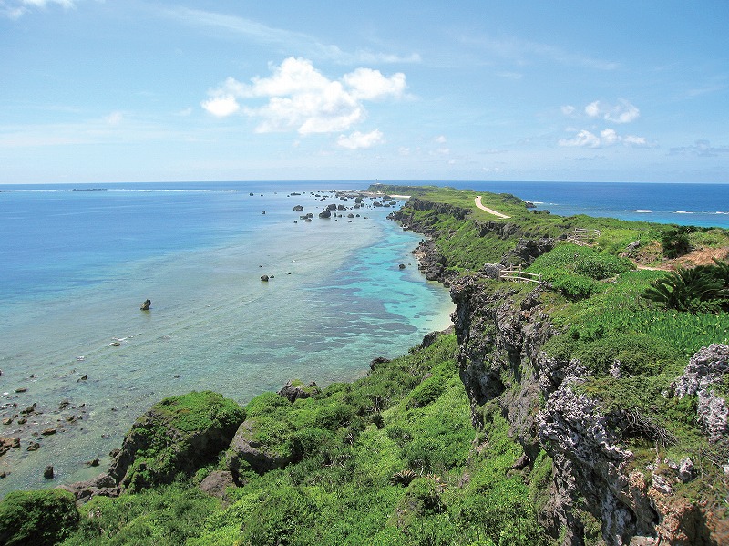
宮古島の東端に細長く突き出た全長約2km、幅30m・150mの岬で、琉球石灰岩のカルスト地形に固有の海岸性植物群落が展開する独特の自然環境とともに、特有の伝承を持つ美しい景勝地として知られる。周囲絶壁は琉球石灰岩の海食崖に囲まれ、標高約20mの平坦面は海食低位段丘を成し全体として海側に向かって突き出し、段丘面は、洞穴、ウバーレなど凹地形が形成されている。
地表面には琉球石灰岩の岩塊が散在し、特に岬の先端部周辺には「津波石」と名付けられた径約6.8mにも及ぶ岩塊、さらに東方海域の離礁上にも「パナリ」と呼ぶ巨大な岩塊等が点在する。この一帯の海域は荒波と言われ、通年の強風により高木は育たず、亜熱帯地方の風衝地特有の植物群落が発達している。特にテンノウメ群落の分布面積は他に類例を見ないほど大規模である。また、東平安名崎の優れた風致景観は、宮古島の按司と美しい娘との恋にまつわる悲しい伝承を生み、彼女の墓地とされる(岩陰墓)なども残っている。宮古島の風土的特色を代表する景勝地として、鑑賞上又は学術上の価値は高い。
海域追加指定|2011年2月7日
【National Designation:Place of Scenic Beauty】Cape of Higashihennnazaki
Located at the eastern end of Miyakojima, the cape is a narrow protrusion of approximately 2km in total length, and 30m-150m in width. It is blessed with a unique natural environment, where indigenous coastal plant communities can be seen dispersed on the karst landform of Ryukyu limestone. The scenic beauty of the location is told in unique lore.
The surrounding cliffs of the cape are Ryukyu limestone formed into coastal cliffs. The flat area at about 20m above sea level is the lower terrace of the sea cliff, and the cape in general protrudes towards the sea. The terrace surface has caves and uvala and other concaves and depressions on the landform.
Scattered on the ground are lumps of Ryukyu limestone rocks, and in particular, found at around the tip of the cape, there is a large mass of rock around 6.8m in diameter, named Tsunami Ishi, and another huge mass of rock called Panari on the reef in the waters to the east of the cape. The waters in this area are said to be rough, and with the strong winds all year round, tall trees do not grow here, but instead, growths of plant communities particular to wind-swept areas in the subtropics can be found. In particular, the growth and distribution of Tennoume communities is of a significant scale that cannot be seen often elsewhere.
The breathtaking beauty of Higashihennna Cape is also highlighted by the traditional lore told on Miyakojima, a sad love story between an Aji chieftain and a beautiful girl. The tomb of the girl is at the shadows of the rocks where she is laid to rest. The cape is a beautiful location that highlights the distinguishing cultural characteristics of Miyakojima, and is also a valuable location to appreciate the scenic beauty and to achieve an academic understanding of the area.
Additional designation of the water area: February 7, 2011
【國家指定:名勝】東平安名崎
東平安名崎是一個位於宮古島東端的細長突出的海角,全長2km,寬30m~150m。琉球石灰岩的喀斯特地形上,生長著固有的海岸性植物群落,自然環境非常獨特。同時,還作為一個擁有獨自傳說的美麗風景勝地而廣為人知。
周圍的絕壁被琉球石灰岩的海蝕崖包圍,海拔約20m的平坦表面構成海蝕低位臺地,整體面向海洋突出,臺地表面散布著琉球石灰岩的岩塊,尤其在海角的先端部周圍有一個直徑達6~8m,名叫「津波石」的岩塊。另外,在東方海域的離礁上也有幾個名叫「帕那利」的巨大岩塊。這一帶的海域海浪洶湧,常年吹著強風不適合高大樹木的生長,相反在亞熱帶地區的風衝地常見的植物群落卻生長的很茂盛。特別是磯山椒群落的分佈面積之大是其它地方無法與之比擬的。除此以外,東平安名岬的出眾景觀還醞釀出了宮古島的按司和美麗女子之間的一段悲戀傳說,據說,女子的墳墓(岩陰墓)留存至今。東平安名岬作為代表宮古島風土特色的觀光勝地,具有極高的觀賞性和學術性的價值。
海域追加指定| 2011年2月7日
【정부 지정:명승】히가시헨나자키 갑
미야코섬 동쪽 끝에 돌출해있는 길이 약 2km, 폭 약 30m-150m의 곶이다. 류큐 석회암의 카르스트 지형에 고유의 해안성 식물 군락이 전개하는 독특한 자연환경과 더불어 특유의 경관을 자랑하는 아름다운 관광지로 알려져 있다.
주위 절벽은 류큐 석회암의 해수 침식 절벽으로 둘러쌓여 있고, 표고 약 20m의 평탄한 면은 해수로 침식된 낮은 언덕을 이루고 있다. 전체적으로 바다쪽으로 튀어나와 있고, 언덕 표면은 동굴, 우바레 등 오목한 지형으로 형성되어 있다.
지표면에는 류큐 석회암의 돌덩어리가 산산이 흩어져있고, 특히 곶 앞쪽 끝 주변에는 “쓰나미 돌”이라는 이름의, 직경 약 6.8m나 되는 바위 덩어리가 있다. 동방 해역의 이호離礁 상에도 “파나리”라고 불리는 거대한 암석 덩어리 등이 점점이 존재한다. 이 일대의 해역은 파도가 거칠고 일년 내내 강풍이 불어 키가 큰 나무는 자라지 못한다. 아열대지방의 풍충지 특유의 식물 군락이 발달되어 있다. 특히 덴노우메 군락의 분포 면적은 유례를 찾아 볼 수 없을 정도로 규모가 크다.
또한 히가시헨나자키의 우수한 풍치경관은 미야코섬의 아지와 아름다운 처녀의 사랑에 관한 슬픈 전설을 낳았는데, 그녀의 묘지라고 전해지는 (바위그늘 묘) 등도 남아 있다. 미야코섬의 풍토적 특색을 대표하는 경관으로써 감상은 물론 학술적 가치도 높은 곳이다.
해역 추가 지정 2011년 2월 7일
![]()
生涯学習部 生涯学習振興課
電話:0980-72-3764