


トップ > 市の組織 > 教育委員会 > 生涯学習部 > 生涯学習振興課 > 【国指定史跡】 先島諸島火番盛「遠見番所」 狩俣遠見
【国指定史跡】 先島諸島火番盛「遠見番所」 狩俣遠見
〔さきしましょとうひばんむい「とおみばんしょ」かりまたとおみ〕
宮古島市の6ヵ所(池間、狩俣、島尻、大神、来間、砂川)が、他の12カ所と共に一つの史跡として登録されている。
江戸時代、鎖国体制下の1644(順治元)年に、薩摩藩支配の琉球王府によって設置された、海上交通の監視・通報(烽火:のろし)機能をになった遠見番所跡群。先島諸島は琉球列島の最西端に位置し、東シナ海の緊張に直面しており、対外関係と鎖国体制の完成を示す遺跡として重要である。
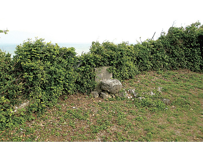
狩俣集落後方の丘の上にあって、方位を刻した円柱形のピャイイス(方位石)が設置されている。狩俣では明治の末頃まで「遠見番屋」(壁・石積・屋根瓦・約3 坪)が遺されていた。この遠見は主として沖縄本島を往還する上国船、漂流船の発見・監視など、広く海上警備の役割を果たしていた。伝承によると、この遠見には遠見番が日夜、交替で海上の監視にあたり、船影を発見すると、すぐさまブンミャー(村番所)の役人に連絡をとったという。ブンミャーにはソーカツ(総聞)、ユーサズ等の役人が詰めていて、船影発見の連絡を受けると急ぎ、集落の農民をピャーツカイ(伝令)として蔵元へ走らせたと言われている。
【Historic Site Designated by the Nation】 Sakishima Islands Hibanmui “Tomi-bansho (Lookout)” Karimata Tomi (Karimata Lookout)
Six points in Miyakojima City (Ikema, Karimata, Shimajiri, Ogami, Kurima, Uruka) with other 12 ones are designated as on historic site.
These sites are lookouts points that functioned as observation and reporting (using beacon fire) stations, watching over the maritime traffic. They were established by the Ryukyu government controlled under the Satsuma Clan during the Edo period, during the time when the nation was closed to the outside world in 1644. Located at the westernmost point in the Ryukyu Archipelago, the Sakishima Islands directly face the tensions in the East China Seas, and therefore, these lookouts are significant sites as they complete the closure of the nation at the time from the outside world.
Located atop a hill behind the Karimata settlement, the lookout has a column-shaped stone compass, or Peiisu (pronounced pee-isu) set here. Until the end of the Meiji era (1868-1912), the lookout site remained in Karimata (approximately 10m2, which included the walls, piled stones and roof tiles). The main function of this lookout was to oversee national ships going to and from Okinawa Island, and to search and discover derelict ships, and it played a broad role in guarding the waters of this area. According to lore, the lookout was manned on rotation day and night, and once the men on guard spotted at ship, they would immediately report to the Bunmya, or the village guard. Sokatsu and Yusazu officials were stationed at the Bunmya, and when they received notice of a ship, they sent farmers as Pyatsukai or messengers to the general overseer in charge.
【國家指定史跡】 先島群島火番盛「遠見番所」狩俣眺望臺
宮古島市內有 6 處(池間,狩俣,島尻,大神,來間,砂川)與其他 12 處一起被登記為單一史蹟。
江戶時代,正處於鎖國體制下的1644(順治元)年,薩摩藩統治下的琉球王府設置的具有監視海上交通和通報(烽火臺)功能的眺望臺守衛站遺跡群。先島群島位於琉球列島的最西端,時刻面對著東海的緊張局面,眺望臺守衛站體現了當時日本的對外關係和鎖國體制的完成,是很重要的遺跡。
狩俣遠見位於狩俣村落後方的山丘上,設有彫刻著方位的圓柱形方位石。直到明治末期,狩俣有個「遠見番屋」的遺跡(牆壁・石堆・屋頂瓦・約10平方公尺)。這個眺望臺主要進行尋找和監視往返沖繩本島的本國船及漂流船等廣汎的海上警衛活動。據說眺望臺的守衛日夜輪流監視海上船隻,一旦發現有船影就立刻通知Bunmyaa(村警衛所)的職員。Bunmyaa裡常駐著Sokatus(總聞)、Usazu等職員,一收到發現船影的聯絡,就讓村落的農民做為傳令,跑去管理倉庫的官員處彙報。
【국가 지정 사적】 사키시마 제도 히반무이소 “도미반쇼(정찰소)” 가리마타 토미
미야코지마시의 6곳(이케마, 카리마타, 시마지리, 오가미, 고마, 사가와)이, 다른 12곳과 함께 하나의 사적으로서 등록되어 있다.
에도시대 쇄국체제하 1644년(순치1년), 사쓰마번 지배의 류큐 왕정부에 의해 설치되었다. 해상 교통의 감시와 통보(봉화) 기능을 맡은 도미반쇼(정찰소) 유적지. 사키시마 제도는 류큐열도 최서단에 위치하여 동중국해의 긴장과 직면하고 있어, 대외관계와 쇄국체제의 완성을 알리는 유적으로써 중요하다.
가리마타 마을 뒷쪽 언덕 위에 위치하며, 방위를 새긴 원주형의 피이스가 설치되어 있다. 가리마타에는 메이지시대 말경까지 “도미반야”(벽, 돌, 기와, 약 3평)가 남아 있었다. 이 도미반쇼는 주로 오키나와 본도를 왕래하는, 류큐왕정부에 출장가는 사람을 태운 배, 표류선의 발견와 감시 등, 널리 해상 경비의 역할을 맡았다. 전설에 의하면 이 도미반쇼에는 도미 당번이 밤낮 교체로 해상 감시를 맡아, 배를 발견하면 곧 분먀(마을 관리소)의 관리자에게 연락을 취했다고 한다. 분먀에는 소카쓰(総聞) 유사즈 등의 관리가 배치되어있어, 배를 발견했다는 연락을 받으면 급히 마을 농민을 퍄쓰카이(전령)로써 파견했다고 한다.
![]()
生涯学習部 生涯学習振興課
電話:0980-72-3764