


トップ > 市の組織 > 教育委員会 > 生涯学習部 > 生涯学習振興課 > 【市指定:天然記念物・地質】ツヅピスキアブ
【市指定:天然記念物・地質】ツヅピスキアブ
〔つづぴすきあぶ〕
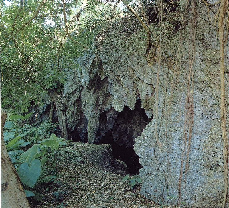
平良字下里大原地区の丘陵地にあって、「ツヅキピスキアブ」「ツヅヒキホラ」とも呼ばれ、市内では最大規模の洞穴である。その特徴としては、
①洞穴北端の陥没開口から南端開口部にかけて長さ約85mの貫通型の広い横穴である。
②洞穴北端前方にはドリーネ(陥没地)が発達し、オオクサボク・クワズイモ等の環境指標植物が見られる。
③洞床は堆積物が厚く、流水・プールはないが、ベルホールが発達していて自然の造形美・神秘さを漂わせている。
④中位段丘に形成された横洞穴として、過去の宮古島の原形や高海水面時代を推測するのに貴重な要素を有している。
⑤洞床の堆積物からシカの化石が発掘されるが、広く発達した横穴の状況から、他の動物化石発見の可能性もある。
この「ツヅピスキアブ」は、沖縄本島と同様に第三紀層堆積後の琉球珊瑚海時代(約数十万年前)に堆積した貝・サンゴ等の堆積物が、地殻変動や海水面変動によって隆起、陸化(10~15万年前)した後、雨水などによる浸食作用によって形成されたものと推測され、城辺地区の仲原洞穴、上野地区のピンザアブとともに古い時代の洞穴と考えられている。
【Designated by the City:Natural Monument (Geological Feature)】Tsuzupisukiabu
Located at the hills of Ohara, Shimozato in Hirara, and also referred to as Tsuzukipisukiabu or Tuzuhikihora, this is one of the largest caves found within the city. It has the following characteristics:
1. It has a long horizontal passage, measuring approximately 85m in length from the depressed opening at the northern part of the cave to the opening at the southern end.
2. Doline depressions have developed in the front area of the northern end of the cave, and we can see environmental indicator plants such as the Okusaboku, Asian taro, and others.
3. The cave floor is thick with deposits and although there are no flowing water or pools, there is a well-developed bell hole, showing the formative and mystic beauty of nature.
4. As a horizontal cave found at the middle terrace of the hills, it has important features that give us a glimpse of the original form and the period of high sea level in Miyakojima.
5. Deer fossils have been unearthed from the deposits on the cave floors, and as the horizontal cave is widely developed, there are possibilities that other animal fossils are waiting to be discovered.
It is believed that the Tsuzukipisuabu was formed through rain and other erosion, after the deposits of the tertiary period, when the accumulated shells and coral formed protrusions and emergence through crustal movements and eustatic changes in the period of Ryukyu Sango-Kai period (approximately several hundred thousand years ago). It is believed to be a cave from the ancient past, together with the Nakahara Cave in the Gusukube district, and the Pinzaabu in the Ueno district.
【市指定:天然紀念物(地質)】腰原嶺洞穴(赤茲匹速基阿布)
位於平良字下里大原地區的丘陵地,也叫「赤茲匹速基阿布」或「赤茲希基阿或拉」,是市內最大、規模的洞穴。其特徵為:
①範圍從洞穴北端的塌陷開口到南端開口部,長達85公尺的貫穿型寬廣橫洞。
②洞穴北端的前方有許多石灰坑,可以見到皮孫木、姑婆芋等環境指標植物。
③洞床上的堆積物很厚,雖然沒有流水和水窪,但鍾形孔很發達,洋溢著自然的造型美和神秘感。
④做為形成於中位階地的橫洞穴,具有推測古時宮古島的原形和高海水面時代的珍貴要素。
⑤從洞床的堆積物中,出土鹿的化石,因此,有 可能在寬廣的橫洞中,發現其他的動物化石。
這個「腰原嶺洞穴」與沖繩本島的形成過程相同,在第三紀地層堆積後的琉球珊瑚海時代(大約數十萬年前)由堆積起來的貝殼珊瑚等之堆積物,再因地殼變動和海水面變動等原因而隆起,變成陸地(10~15萬年前)後,受到雨水等侵蝕作用而形成的。與城邊地區的仲原洞穴、上野地區的平扎布洞穴一樣都屬於古代的洞穴。
【미야코지마시 지정:천연 기념물 (지질)】쓰즈피스키아부 동굴
히라라 아자 시모자토 오하라 지구의 구릉지역에 있고, “쓰즈키피스키아부”, “쓰즈히키호라”라고도 불린다. 미야코지마 시내에서는 최대 규모의 동굴이다. 다음과 같은 특징이 있다.
① 동굴 북단의 함몰개구에서 남단개구부에 걸쳐 길이 85m의 넓은 관통형 횡혈이다.
② 동굴 북단 전방에는 함몰지역이 발달되어 피소니아, 알로카시아 등의 환경지표식물을 볼 수 있다.
③동굴 바닥은 퇴적물로 두껍다. 흐르는 물이나 헤엄칠 수 있는 곳과 같은 곳은 없지만 벨홀이 발달되어 있어 자연의 조형미와 신비로움이 감돈다.
④ 중위 단구에 형성된 횡혈동굴로써 과거의 미야코섬의 원 모습과 고해수면시대를 추측하는데 있어 귀중한 요소이다.
⑤ 동굴 바닥의 퇴적물에서 사슴의 화석이 발굴되었는데, 널리 발달한 횡혈의 상황을 보면 다른 동물의 화석 발견 가능성도 있다.
이 “쓰즈피스키아부”는 오키나와 본도와 마찬가지로 제3기층 퇴적 후의 류큐산호해시대(약 수십만년 전)에 퇴적한 조개, 산호초 등이 지각 변동과 해수면 변동으로 융기, 육화(10-15만년 전)를 거친 후, 빗물 등의 침식작용으로 형성된 것으로 추측된다.
구스쿠베 지역의 나카하라 동굴, 우에노 지역의 핀자아부와 함께 옛시대의 동굴로 여겨진다.
![]()
生涯学習部 生涯学習振興課
電話:0980-72-3764